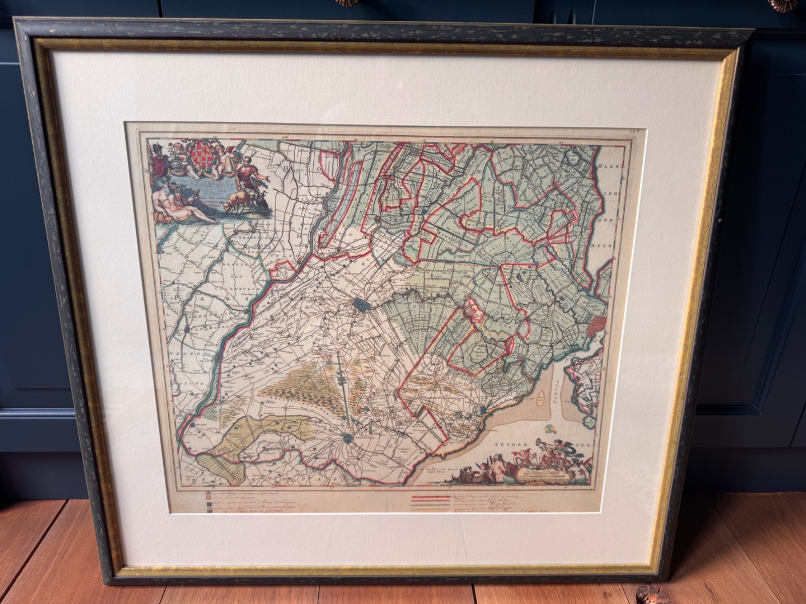
Antique Map of Holland and Utrecht by Willem Janszoon Blaeu, c. 1650-1660
QUICK FACTS
Categories
Era
c. 1650-1660
Origin
🇳🇱 Netherlands
Brand
Blaeu (likely Joan Blaeu or Willem Janszoon Blaeu's firm)
Artist/Maker
Willem Janszoon Blaeu (likely the father or son from the Blaeu workshop)
Rarity
Uncommon (5/10)
Discovered
Feb 23, 2026
5 days ago
DESCRIPTION
This appears to be an engraved map depicting the regions of Holland and Utrecht, with the Zuiderzee prominently featured. The cartographic style, decorative cartouche, and mythological figures in the Zuiderzee suggest a mid-17th-century Dutch origin. The use of hand-coloring, likely contemporary or early, enhances the legibility of the political boundaries and geographic features, which was a hallmark of Dutch cartography during its Golden Age. The map is framed, indicating it's been prepared for display and preservation.
CULTURAL ECHOES
Where This Object Echoes
The 17th century saw the Netherlands emerge as the preeminent power in mapmaking, with families like Blaeu establishing a standard for detail, accuracy, and artistic embellishment that influenced cartographers worldwide.
The decorative cartouches and mythological figures, often incorporating classical imagery and allegories, were common artistic conventions of the period, making these maps overlap with fine art.
Ritual & Ceremonial Use
- •The acquisition and display of such maps by wealthy merchants and nobility, serving as an emblem of wealth, education, and an expanding worldview in their private studies or public parlors.
- •The practice of binding these individual sheets into large, lavish atlases, signifying a comprehensive understanding and mastery of the known world.
Meaning Through Time
Primarily served as both practical navigational and administrative tools, and as potent symbols of national pride, intellectual curiosity, and colonial ambition.
Gradually shifted from practical use to historical documents, appreciated for their antiquated geographic representations and their artistic merit.
Became highly sought-after collector's items and decorative art pieces, valued for their historical significance, craftsmanship, and aesthetic appeal, often removed from their original atlas context.
HISTORICAL STORY
DID YOU KNOW?
The Blaeu family workshop in Amsterdam, beginning with Willem Janszoon Blaeu, produced some of the most beautiful and accurate maps and atlases of the 17th century, often considered masterpieces of cartographic art.
The 'Zuiderzee' (Southern Sea) depicted in the map was a large inland bay in the Netherlands that was largely dammed off in 1932 to form the freshwater IJsselmeer, a significant Dutch engineering feat.
MATERIAL & CONDITION
Surface
The paper surface exhibits characteristics consistent with 17th-century engraving, including evident plate marks and a creamy, aged paper tone. The coloring appears to be original hand-coloring, with certain features highlighted in red, green, and yellow washes. There are some signs of possible light foxing or age-toning visible.
Weight & Feel
Given its age and presentation as an engraved print on period paper, the item itself is quite light, though the modern framing would add substantial weight and bulk. The paper is likely a laid paper, providing a distinct texture.
Condition
The map appears to be in good collectible condition, framed and likely protected behind glass. There is some visible age-toning and potentially minor foxing consistent with a 350+ year old print. The margins seem adequate, not trimmed into the plate mark, which is a key factor for antique maps. The coloring is well preserved.
RARITY ANALYSIS
Genuine antiques with fewer examples on the market. Named makers, documented provenance, or early production examples.
Typical Characteristics
- Limited production
- Named makers
- Growing collector demand
EXPERT ANALYSIS
Cartographic Specialist & Antiquarian Dealer
My confidence is high due to the distinctive style, immediately recognizable decorative elements, and identifiable region consistent with a renowned cartographer like Blaeu. The visible geographical features and ornamental border align strongly with known Blaeu works from the mid-17th century, specifically his atlas maps of the Low Countries.
KEY EVIDENCE
- 1Decorative cartouches and mythological figures in the sea, highly characteristic of 17th-century Dutch cartography.
- 2Fine copperplate engraving visible in the detailed lines and topography.
- 3Hand-coloring with clear demarcation of political boundaries and features.
- 4Text 'ZUYDER ZEE' and general design consistent with works by the Blaeu family.
- 5Label in lower left appears to relate to 'Hollandiae et Ultrajectinae Partis Occidentalis' by Blaeu.
UNCERTAINTIES
- •The presence of framing prevents inspection of the verso (back) for watermarks or previous collection stamps.
- •It's difficult to ascertain if the coloring is original contemporary hand-coloring or later skillful enhancement without closer physical examination and comparison.
- •Precise edition (e.g., specific state within the Grand Atlas series) cannot be determined without clearer examination of any textual variants or plate characteristics.
WHAT WOULD IMPROVE CERTAINTY
- →Remove from frame and examine the verso for watermarks, especially against transmitted light, and any publisher's text or stamps.
- →Measure the full sheet size and plate marks (the indentation created by the copperplate) to compare against known dimensions for Blaeu maps.
- →Inspect the coloring under magnification to confirm consistency or signs of later application.
- →Compare the specific geographical details and decorative elements with known states and editions of Blaeu's map of this region (e.g., 'Hollandiae et Ultrajectinae Partis Occidentalis').
ESTIMATED VALUE
Updated: Feb 27, 2026
- Market comparables from auctions & retail
- Condition, completeness & craftsmanship
- Current collector demand & trends
- Low = quick sale, high = patient seller
For informational purposes only, not a formal appraisal.
ABOUT MAPS & GLOBES
Antique maps, atlases, celestial charts, and terrestrial globes.
Browse all Maps & GlobesSHARE THIS CURIOSITY
Have your own curiosities to discover?
Scan Your Curiosity
COMMENTS
No comments yet. Be the first to share your thoughts!
Sign in to leave a comment